An expedition across Iceland’s largest glacier, from where we will follow the watershed back to the ocean by packraft. We will of course, be going Going Norse!
The choice of location and itinerary for this journey matured slowly out of multiple desires and objectives. Having visited Iceland back in 2012 I had already experiences some of its beauty, landscape and difficult weather. It was a cathartic experience and some of my fondest memories are from that trip. I had never before been so cold and wet for so long. Since then I have completed other trips into the wild, often in more extreme conditions, but that first taste has remained very special. Having one of Europe’s largest glaciers (1) and the abundance of wild rivers that traverse a large part of the country was clearly a bonus. The Islandic countryside presents the perfect playing field for the type of expedition we want to complete. It is a challenging environment in which to complete our goals of a multi-sport, unassisted tour, as well as a training ground for future polar expeditions. Our proposed route has slowly evolved but is (to us) an aesthetic line across the country which will hopefully expose us to both its most beautiful and demanding regions.


The traverse
This journey will have two main parts. The first is to cross the Vatnajökul ice-cap. It extends for 8100 square kilometers and is over 160 kilometres in length. It, is of course severely crevassed in places and is therefore a serious undertaking. We are motivated by the bleak landscape and the physical challenge. Having grown up reading the tales about the golden age of polar exploration, with characters such as Shackleton, Mawson and Amundsen leading across the ice, I am passionate about discovering the huge glacial expanses. Crossing Vatnajökul will be a serious adventure, especially due to the strong winds and unexpected weather. It will be both a goal to complete as well as a training exercise for journeys to come. The crossing will be performed on foot, along the south-north axis, taking us into the highlands.


The second part of our travel will be made using packrafts to descend from the high country, back down to the ocean. We will be building on Grégoire’s experience of river kayaking and my solo travels in the Lofoten Islands. By heading north from the glaciers down the river Skjálfandafljót, the forth longest of the country, we will arrive at the bay of Husavik and back to civilisation. The river was first descended entirely by kayak in 1989 by a team from Sheffield University. During the whole trip we will be hoping to get some good pictures of the lunar landscapes and waterfalls. At night we will be looking for the auroras which are dependent on both solar activity and the weather. It will be a question of being ready at the right moment!
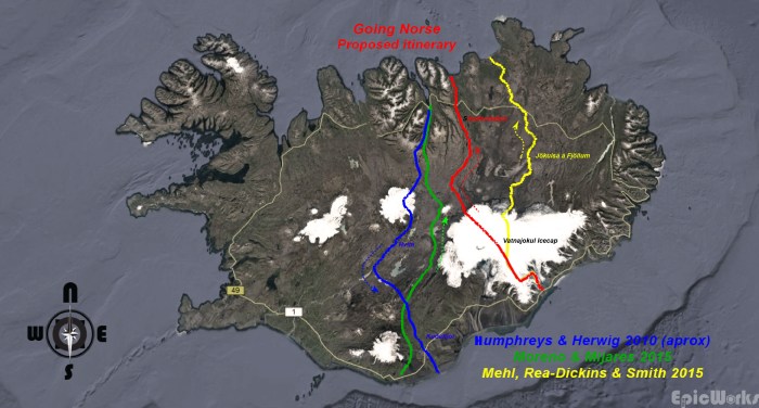
Our planned traverse (red), previous packraft journeys highlighted.
For other trips (Kyrgyzstan, Turkey) I have searched for new exploration and first lines. Iceland in comparison is relatively well surveyed and there have been previous hiking and pack rafting expeditions before us. This being said, to our knowledge there is very little precedent with no outside help at all (re-equipment after the glacier travel), especially in early winter (it already starts to snow in September). To read about previous trips and get a glimpse of what is awaiting us you can click on the following links: Humphreys & Herwig, Moreno & Mijares or Mehl, Rea-Dickins & Smith. We hope to bring back as good a story as they did.
To our knowledge it will be the first trip combining the Vatnajökull crossing and an unassisted packraft descent with no resupply (2). But for us the real interest will be more about discovering the landscape Iceland has to offer and experiencing the weather firsthand. Will it be as bad as I remember? It will be our first autonomous amphibious traverse and we hope to complete it successfully. Finally, this trip will serve as a basis for future polar travel by testing our methods and training for still more ambitious projects.
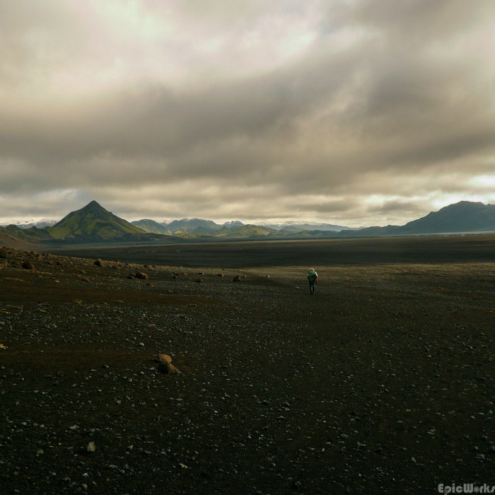
The magical volcanic lanscape of the black deserts
Follow the dots.
We will be trying to update our position at regular intervals, so don’t hesitate to drop by and check out our progress on the map. We might even be able to send a message or two, so don’t hesitate to check it out:
https://eur-share.inreach.garmin.com/GoingNorse
The wanderers
There will be two of us for this journey, myself and Grégoire. I was brought up on the sunny coast near Barcelona where snow is over before breakfast. After first hikes in the Pyrenees I moved to the Alps with the excuse of getting a PhD in physics and proper winters. Graduating from day trips to longer unsupported travel, over the last few years I’ve travelled on skis in Kyrgyzstan, Turkey and Iran, by bike in Tibet and Europe, kayak in Lofoten, British Columbia and Sardinia as well as countless hikes in the Alps. I enjoy photography in all formats, from developing film to aerial drone landscapes. Organising an expedition is both a way of getting outdoors and visiting places that would otherwise be impossible for me to see, as well as being a logistical and physical challenge.
Grégoire was born in the French Alps and spent his childhood hiking in the mountains surrounding his birthplace. Moving to Brittany gave him the opportunity to discover white-water kayaking and sailing, before arriving in Grenoble, also for a PhD. This is where we met. He has since moved to California for 2 years and is currently discovering the Sierra Nevada Mountains. Our first unsupported tour together was on cross country skis in the Yllas-Pallas region in northern Finland during the spring of 2016.
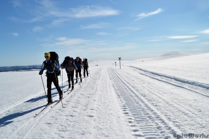
Myself and Gregoire during our Finnish traverse, in second and third place respectively. 2016, courtesy A. Dobri.
Preparations
With our departure imminent, we are currently finishing the last details, be it uploading waypoints on the GPS, checking maps and completing the list of gear needed. As we will be carrying all our equipment we are continually making trade-offs between performance, weight and necessity. Although I am used to preparing these types of trips, taking into account our mode of travel I have rarely found it so difficult to make the final choices. Starting with the packrafts and paddles, we will also need everything for camping as well as harnesses and ropes for crossing the glacier. We have been lucky enough to have some companies support us for the challenge and we are extremely grateful for their confidence in us. We would like to thank Kokopelli Packraft, Au Vieux Campeur and Blue Ice for backing us in this venture and we can’t wait to try out their products on the terrain. In the meantime, here are some shots of us testing and packing our gear as the date approaches…
And remember, we hit the trail September the 16th!


Tasting the river! A quick after-work run down the Romance.
(1) Vatnajókul is the largest glacier in Europe by volume, not counting the Severny Island ice cap on the Novaya Zemlya archipelago in Russia.
(2) The Mehl/Rea/Smith team where resupplied after the glacier and did not carry their packrafts across the ice.

C’est super ce que vous allez entreprendre. Entrainement et préparation difficile, expédition gagnée !
Bonne expédition sur cette Ile magique.
Signé, Frédéric (père de Grégoire)
LikeLike